 Rating: 4 - 1562 Reviews


MapStudio's Botswana Travel Map [Review]
Roadmaps have always been a welcomed and ever-present accessory in the arsenal of any true adventure traveler. Whether you want to rough it out, plan your next trip into Botswana, or just want to make sure you’re covered the next time your GPS lets you down on your wildlife expedition, this Botswana travel map will be there to assist you in any navigational dilemma.
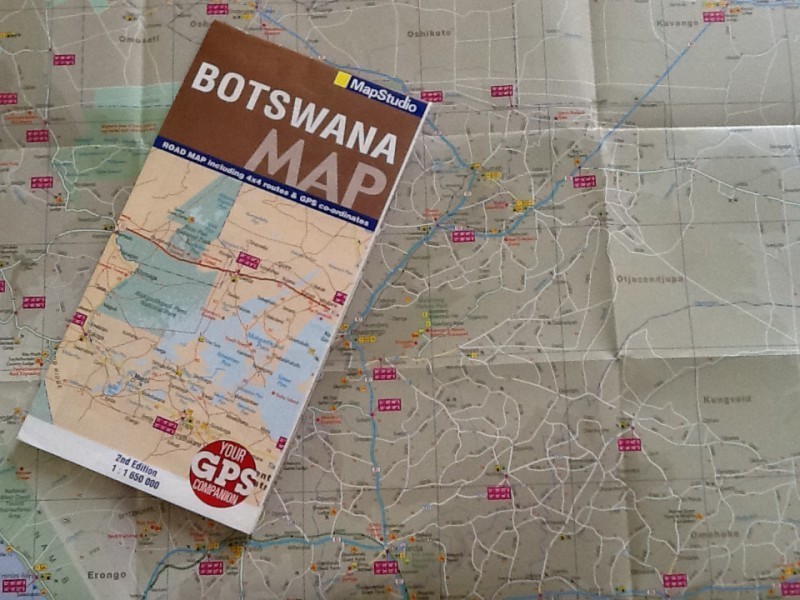
Above: Travel map of Botswana
MapStudio’s informative and highly detailed, easy to read and full-color roadmap of Botswana will assist you in planning the trip of a lifetime. This revised edition of the Botswana roadmap contains everything a true adventurer embarking on a trip will essentially need and more.
More than just a roadmap of Botswana…
Well researched and up-to-date features include: an initial 1:1650 000 scale map indicating some of Botswana’s best 4×4 routes; clearly marked for your convenience, detailed GPS coordinates; to be used in conjunction with any navigation system and coverage on places of interest, namely national parks and reserves; in and around Botswana’s borders.
The Botswana travel map’s segment regarding national parks and reserves is truly unique, supplying one with extensive information on the background of the parks/reserves, accommodation, contact details, entrance times, park regulations and a ‘to see’ list.
Parks and reserves mentioned in the travel map of Botswana include:
• Chobe National Park
• Makgadikgadi Pans National Park
• Nxai Pan National Park
• Khutse Game Reserve
• Moremi Wildlife Reserve
• Central Kalahari Game Reserve
• Kgalagadi Transfrontier Park
• Okavango Delta
What else does the Botswana travel map offer?
Other well-designed elements of the Botswana map include detailed location street maps of both Gaborone and Francistown (the two larger cities in Botswana) as well as climate statistics for yearly rainfall and temperature figures.
An alphabetical index, a detailed distance chart (of thirty-one towns in Botswana), country facts and figures and a list of tour operators throughout Botswana are also added to create a map truly rich in content.
Another helpful feature is the positioning of neighboring counties such as Zimbabwe, Zambia, Namibia, and South Africa, as well as a key plan of the detailed maps. Other interesting features of the Botswana travel map that aren’t found in other generic roadmaps of Botswana are the vibrant, colorful images such as springboks trekking through the Kalahari bushveld, a young lion taking cover from the midday sun and even an image of elephant-back safaris in the Okavango Delta.
The final result of MapStudio’s Botswana map?
While I do believe this is an exceptional product, pushing the envelope of what travelers have come to expect from roadmaps, I do feel that, in an age where technology is integrated in almost every facet of our lives, MapStudio would find it well received if they were to release the Botswana travel map in a digital format.
Related Posts
Is Johannesburg Safe?
Background information about Johannesburg Johannesburg is the biggest city in South Africa and the economic capital of Africa. The city is home to the Johannesburg Stock Exchange which is Africa’s largest stock market. The ‘city of gold’ is the richest city in Africa with the highest concentration of high net worth individuals in Africa, but […]
Read MoreThe BEST Overlanders you Should be Following
This blog will outline the best Overlanders in South Africa, who are filled with stories and different experiences that will take your breath away. At Drive South Africa we are passionate about driving and there is nobody better to share that experience than these overlander kings and queens of South Africa. These Drivers have […]
Read More10 Tips for Sustainable Tourism
For many eco-conscious travellers, sustainable tourism isn’t just a preference – it’s a necessity. The tourism industry represents hope for some of the most stunning natural places around the world. However, but without sustainable tourism practices, it’s also a threat. Tourism’s economic benefits compete with potential ecological and social problems that come with heavy traffic. […]
Read More