
5 4x4 Rental Mistakes You’ll Want to Avoid
The lure of the open road draws thousands of adventurers to Southern Africa every year....
 3 July 2026

Searching...
Botswana is now the second African country to offer Google Street View, which is part of the free Google Maps service.
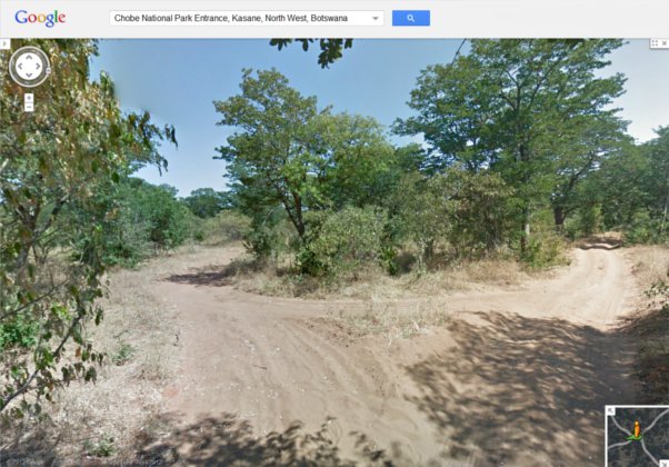
Above: Chobe National Park
Internet users from around the globe now have the opportunity to virtually explore the streets of Gaborone, Francistown, Maun and Kasane. The major highways and roads in Botswana are also covered by the service, as well as the Makgadikgadi Pan, Chobe National Park and the Okavango Delta (the world’s largest inland river delta).
The Google image capturing streetcar was replaced by a 4×4 vehicle to photograph tricky off-road areas.
“Whether you are planning a safari, doing a homework assignment on Botswana, or promoting your local business, Street View will allow you to experience a slice of the country,” said Ory Okolloh, policy manager for Google Sub-Saharan Africa.
Currently, Google Street View has brought its panoramic street-level images of over 30 countries to the public.
The lure of the open road draws thousands of adventurers to Southern Africa every year....
3 July 2026 
Planning your first self-drive adventure across Southern Africa is an incredible milestone, but it quickly...
26 June 2026 
There’s nothing quite like the anticipation of rolling through the gates of Kruger National Park...
19 June 2026 


Typically responds in under 15 minutes